Posted on

Mulberry Harbor & The Delta Works

Our topic today is inspired by a trip we took to the Netherlands in May 2023. One of the excursions was to the Delta Works, a massive decades-long engineering project to protect the Dutch from devastating floods in the southern part of the Netherlands.

Little did I know when I signed up for the excursion that the museum we would tour was connected to the Normandy invasion on 6 June 1944 and the ensuing deployment of men, armaments, and supplies used to support the Allies as they broke out of Normandy on the path to Germany.

The museum, Watersnoodmuseum, or “Flood Museum” is located inside four concrete caissons built to be used as part of the two artificial Mulberry Harbors at Arromanches-les-Bains (or simply, Arromanches) and Saint-Laurent-sur-mer, France.
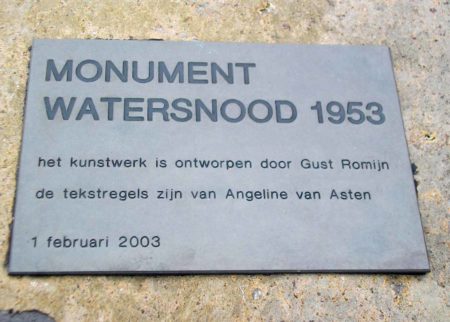
Commemorative plaque at the Watersnoodmuseum identifying the “Monument Watersnood 1953.”
Commemorative plaque at the Watersnoodmuseum identifying the “Monument Watersnood 1953.” Photo by Rene1971 (2 September 2006). PD-CCA-Share Alike 3.0 Unported. Wikimedia Commons.

Did You Know? 

Did you know that we recently ran across rats in the Tiergarten during our visit to Berlin? Yep, it was a similar experience from years ago while we were walking in a Parisian park next to the Seine. After I returned to the states, I found out there was an organized movement in Paris to befriend those friendly furry rodents and I wrote a blog in 2018 on Paris rats (click here to read the blog, Paris Therapy Pets). Fast forward now to several months ago when the newly elected mayor of New York City created a new position and appointed someone to deal with the city’s massive rat problem. (Mayor Adams has been fined several times because his house is infested so I figure he wanted a hot line to someone who could come right away and get rid of his invasive rodents.)

Well, what do I see the other day? No, not more rats but rather a CNN article entitled “Can humans and rats live together? Paris is trying to find out.” It seems to be a bona fide question the Paris politicians are trying to answer. Mayor Hidalgo has formed a committee to study “cohabitation” with the rats while the center-right party is calling for more aggressive action against the proliferation of rat populations. They argue that rats are harmful to the quality of life. The pro-rat organization, Paris Animaux Zoopolis (PAZ), disagrees as do senior members of the Paris government. Paris rats do not pose a public health risk and “we need scientific advice,” says the deputy mayor. I guess she never studied the history of medieval Europe.

So, what does “cohabitation” with the rats mean? According to PAZ, “. . . making sure (rats) don’t suffer and that we’re not disturbed.” I suppose that is what is meant by “having your cake and eating it too.” That is, until the rats eat the cake first. At that point, the old French saying, “Let them eat cake” becomes relevant and solves the problem.

Rats can often be seen on the streets of Paris despite extermination efforts. Photo by Christian Hartmann (date unknown). Reuters/CNN.

The Invasion and Mulberry Harbor 

I think everyone is familiar with D-Day and the invasion of Normandy on 6 June 1944 (Operation Overlord, or simply “Overlord”). However, not everyone knows about the two artificial harbors (“Mulberry”) used to facilitate unloading supply ships with the materials necessary to sustain an advancing army. I’m also pretty sure most don’t know the story of Operation Fortitude which was a series of Allied deception plans intended to make Hitler and his senior staff think Normandy was a diversion and the real invasion would take place at Pais de Calais. (Click here to read the blog, The Double Cross System.) Read More Mulberry Harbor & The Delta Works

Posted on

Powerful Images

I ran across an article several months ago that immediately captured my attention. It was a photograph that sent chills down my spine. I said to myself, “Now that’s a very powerful image.”

I thought about the story behind the photograph and decided to write a blog about powerful and iconic images from World War II. Unfortunately, we can only include twenty-five photographs in this blog. However, there are hundreds if not thousands of other photographs that would fit into the theme of this blog. If interested, you can check out various web sites listed below to view some of the other photographs we did not include.

Please be warned that some of the images included in this blog are very disturbing.

We begin our photographic journey with the Hanukkah menorah in the window. It is the image that inspired me to write this blog.


Did You Know?

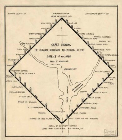
Did you know that nearly all forty of the original Washington D.C. boundary stones are hidden in plain sight? The capital city of the United States was originally a ten-mile by ten-mile diamond shape. These stones marked the boundaries of the city, and they are the oldest federally placed monuments in the United States.

Chart showing the original boundary milestones of the District of Columbia. Map by Fred Woodward (c. 1906). PD-Expired copyright. Wikimedia Commons.

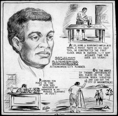
Andrew Ellicott was hired to chart out the new city, but the surveyor needed an assistant to read the stars to ensure the markers were placed accurately. Benjamin Banneker, an African American, was recommended to Ellicott. He questioned the competence of a Black man who had no formal schooling or scientific training. Faced with no alternatives, Ellicott hired the amateur astronomer to work alongside him. For six nights, Banneker lay on his back to record the stars and with those calculations, the first marker stone was placed at Jones Point. (You can see the stone through a window in the seawall of the 19th-century Jones Point Lighthouse.)

Benjamin Banneker, astronomer and city planner. Illustration by Charles Henry Alston (c. 1943). U.S. National Archives and Records Administration. PD-U.S. Government. Wikimedia Commons.

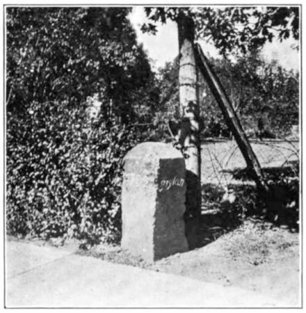
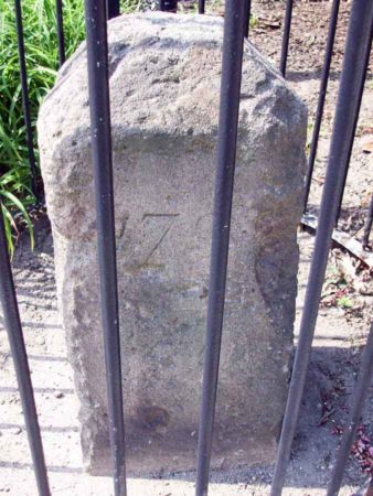
The stones are one foot square and three feet high. They were placed one mile apart and each is numbered according to its quadrant and location. Each side bears the inscription of either “Virginia” or “Maryland” depending on its border state. Other information inscribed on the sandstone markers were the words “Jurisdiction of the United States,” a mile number, the date the stone was erected (either 1791 or 1792), and a magnetic compass variance for the stone’s location. Thirty-six stones remain in their original place (some in severe deterioration as sandstone is not the best material for posterity) while three are replicas and one is represented by a simple plaque.

Boundary stone Northeast No. 2. Photo by anonymous (c. 1907). PD-Expired copyright. Wikimedia Commons.

Thomas Jefferson was secretary of state at the time, and he went on record as saying he did not believe Black and enslaved people were of the same standards as White people in terms of brains and physical abilities. Clearly, Jefferson had never met Mr. Banneker.

Boundary stone NE 2 between the District of Columbia and Takoma Park, Maryland. Photo by Bruce Anderson (August 2010). PD-CCA-Share Alike 2.0 Generic. Wikimedia Commons.

The Hanukkah Menorah

Hanukkah menorah on the windowsill of the Posner’s home in Kiel, Germany.

Read More Powerful Images